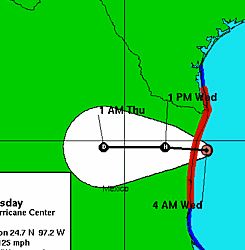
It looks to me like Emily is managing to go ashore just far enough south so the concentrated population along the border will be spared the worst of the wind.
… a strong Category 3 storm … 125 mph … The eye of the storm came ashore just before dawn near San Fernando, a town about 80 miles south of the U.S.-Mexico border. The National Hurricane Center in Miami said hurricane force winds extended outward 70 miles. Tropical storm-force winds blew over south Texas.
I think this side looking radar image (pdf) of the Brownsville-Matamoros area is very cool. You can see how the river has grown more convoluted over time, and also how occationally it folds back on it’s self so that an entire loop is then abandoned. (more maps).
On a more serious note.
expect rains to swamp the low lying ramshackle settlements known as colonias which line the Rio Grande, many of which have no drainage systems…. “It is going to be a very dangerous situation. We could easily see 15 inches of rain in some mountains areas and that will cause flash floods and mudslides,” said Stacy Stewart of the U.S. National Hurricane Center in Miami. …Many fretted over the fate of their modest corrugated iron homes.
(more)